Recently, a regional 3-D ionospheric electron density specification over China and adjacent areas (70oE-140oE in longitude, 15oN-55o N in latitude, and 100-900 km in altitude) is developed by NSSC researchers: A Ercha, Liu Siqing, a s well as other colleagues. This model is established on the basis of data assimilation technique. The International Reference Ionosphere (IRI) is used as a background model, and a three-dimensional variational (3DVAR) technique is used to assimilate both the ground-based Global Navigation Satellite System (GNSS) observations from the Crustal Movement Observation Network of China (CMONOC) and International GNSS Service (IGS) and the ionospheric radio occultation (RO) data from COSMIC satellites. The regional 3D gridded ionospheric electron densities can be generated with temporal resolution of 5 min in universal time, horizontal resolution of 2o×2o in latitude and longitude, and vertical resolution of 20 km between 100-500 km and 50 km between 500-900 km. The data assimilation results are validated through extensive comparison with several sources of electron density information, including: 1) ionospheric total electron content (TEC); 2) Abel-retrieved F3/C electron density profiles (EDPs); 3) ionosonde foF2 and bottom-side EDPs; and 4) the Utah State University Global Assimilation of Ionospheric Measurements (USU-GAIM) under both geomagnetic quiet and disturbed conditions. The validation results show that the data assimilation procedure pushes the climatological IRI model toward the observation, and a general accuracy improvement of 15-30% can be expected. The comparisons also indicate that the data assimilation results are more close to the Center for Orbit Determination of Europe (CODE) TEC and Madrigal TEC products than USU-GAIM. These initial results demonstrate the effectiveness of the data assimilation technique in improving specification of local ionospheric morphology as well as the advantages of the model in generating more reliable and accurate ionospheric information for navigation application. The results were published on the Space Weather hosted by the American Geophysical Union (AGU). (Link: http://onlinelibrary.wiley.com/doi/10.1002/2016SW001363/full)  Figure 1. (left) Daily ionospheric pierce points coverage (green traces) of ground-based GNSS stations (red dots); (right) typical daily distribution of F3/C occultation events. 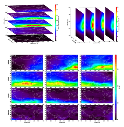
Figure 2: Example of the data assimilation output. (top) horizontal and vertical slices of electron densities. (bottom) regional TEC maps. |